

THE ANCIENT CITY WALLS

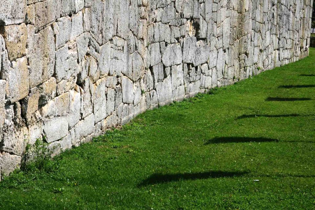
The ancient city walls are one of the most impressive monuments in pre-modern Amelia. The study of the conserved segments has established that an area of about 20 acres were enclosed by the walls. The sections of the town walls that have been preserved through the centuries, surviving wars, integrated with refurbishments and partially reinforced in late Antiquity and the Middle Ages, were originally built with two different techniques: polygonal limestone and classic square travertine.
The walls have an irregular system, shaped according to the topography and adapted to the different exposure of the external territory, that characterizes the northern and southern edges: on the most exposed sides, the S, SE, and SW, the walls extended thick and massive, while on the North, they followed the natural defense system provided by steep slopes overlooking the Rio Grande. At N, NE, NW they clamber up to the overhangs and included in their circuit the highest peaks of the hill: Today, the hospital stands on the North high ground, while the Duomo stands on that on the South-East.
Scholars have different opinions about the timeline of the walls, placing their construction between the late fourth century and the third century B.C. In any case, the erection or reinforcement of the walls fits the prevailing tendencies of that time, when the cities of central Italy progressively entered the political orbit of Rome. A substantial part of the Amelia’s walls, probably the polygonal ones that surrounded the southern part, may have been built after the mid-third century BC, coinciding with the city’s first urban planning. In that period, the Umbrian city assumed the typical features of Roman colonies: a well-defined perimeter enclosing the urban area, within which the public and private spaces were differentiated and punctuated by a regular system per strigas, that is geometric blocks, separated by main roads and byways that crossed at right angles to each other.
The most discontinuous part occurs along the northern slopes, which are steeper and inaccessible. According to recent studies, square travertine walls could be identified on the north-eastern parts, which seem embedded at the base of the medieval fortifications. Parts of the polygonal limestone walls are now incorporated in the cellars of houses, surrounding walls of gardens, and at the base of buildings. On the north-western stretch, conventionally designated with the letter A (via della Valle), the accuracy of execution is inferior. On the eastern section, an ancient gap opened where Porta Leone IV now stands. The most significant part of the walls in III manner polygonal limestone, winds along the slopes S, SE, SW of the urban area (section B): perhaps erected in conjunction with the opening of the Via Amerina, these were able to offer a prestigious image and impressive view of the city to the merchants and travelers from Rome. On the south-west (section C), a segment of different building technique is attributed to a refurbishment at the time of Pope Leo IV (847-855), made with smaller Carnelian blocks: this attribution has been possible thanks to information contained in the Liber Pontificalis (CV, 82). In the same area, a stretch of the ancient fortifications is of uncertain technique and dates back to a refurbishment, probably implemented between the end of the second and the first half of the first century BC, and it is now incorporated in the medieval fortifications.
Some ancient openings opened up along the walls, alongside newer entries: on the north-western side, the medieval Porta della Valle; Porta Posterola belongs to the same period and opens on the NE side; two ancient doors on the eastern side consist of Porta Leone IV and a second opening, brought to light by a bombing during the Second World War (cd. Porta del Sole); on the south-west, a sixth entry with a full round arch was recently brought to light, which is coeval with the construction of the polygonal masonry. But the main city entry opened south towards Rome, on the current site of Porta Romana. In Roman times, the Via Amerina came into the city through this opening, constituting the cardo maximus of the urban center.
Close to the Gate of the Valley, there should be the most ancient city narrow passage, which directly led to the pre-Roman Age Acropolis. The archaic entrance has disappeared, as the ancient city Walls were inner to the Medieval Walls and so they were certainly demolished. However, an imposing section of them remains, and it is characterized by enormous irregular stone blocks, known as megalithic (from greek mégas = big and lithos = stone).
This city walls section is situated a few meters from the Medieval Gate, on the corner of two streets, Via della Valle and Via Piacenti. Above and along the megalithic walls, during the Middle Ages, tower-houses of Guelph and Ghibelline families stood out, with the typical “doors of the dead” (one example of this can still be seen on the facade of Palazzo Nacci in piazza Marconi) and the stone buttresses.